The Viking Canoe Trail, follows a very simple format. We recommend a route that can be completed by a novice canoeist, using non specialised equipment.
Our primary concern is safety and creating a human powered adventure, that is very much in everyone's capability.
We also allow folks to push themselves to see what they can do, which comes at a price.
Below is the rough itinerary of the route, and how we end up at the Viking festival in Schleswig having first challenged ourselves to become a modern day Viking explorer.
The Viking Canoe Trail, starts near Maasholm Harbour the carpark is easily accessible and the small sandy beach make a great sheltered launch spot.
Day 1
Check Point 1 "Timing lap"
Maassholm Harbour - Lighthouse at Estuary of the Fjord where it meets the Baltic Sea and back the launch site
The is a large body of water, and we're using it to get a time and see how the competitor performs in terms of water safety and general boat handling and team structure.
This is a pass/ fail stage it's a critical phase, but makes a very opening stage of the trip
approx distance 3500-4000m
stage 1 "Maasholm- Karschau Camp"
Check Point 2 is at Kappeln Bridge, if you need a break we'll be sited at the southern side of the Schlei checking competitors and making sure everyone is hydrated
check point 3 Karschau Camp where we'll have an evening meal and rest for the following days leg.
approx distance 3500-4000m
Day 2
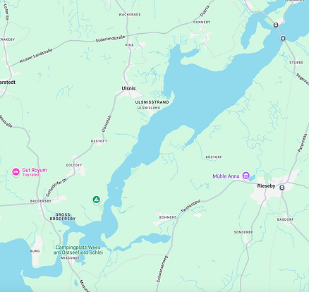
Check point 4 Lindau Camp site access point via slip way
located on the north shore just behind the railway bridge this is another pleasant campsite we're using a check point to ensure everyone is ok.
Timings will be posted, if you arrive outside of the timeslots this will be an enforced stop for the night.
Check point 5 and overnight stop
Camping an De Wees
approx distance 8000m
Day 3
"THE BIG DAY"
this is a marathon section from the previous nights stay it's a weather dependant traverse of the big bit "Die Grosse Breite" and and the slightly smaller bit "Die Kleine Breite"
check point 6 Schleswig Harbour and the start of the overland section to Hollingstedt
approx distance 3500-4000m
Day 3
Overland section
follow the signs of the viking canoe trail along the flat footpath which is situated on the north shore of the Schlei this will lead the competitor to a sigposted section of footpath direction Hollingstedt
check point 7 Hollingstedt
approx distance 10000m
On route to Hollingstedt the competitors will pass the UNESCO site of Danewerk a protected historical location of the large viking age fortifications that sit still visible in the landscape
Check Point 8 Hollingstedt is just past the village over the bridge and visible from the road, this will be our harbour area
It's a campout location with limited services, please pack and prepare for this.
Competitors can have a rest day by the river to gather their thought on the previous days marathon stage
depending on which level of support you've booked
Day 4
The Viking Canoe Trail, now enters the river section
Canoes will need a wipe down to stop any biological transfer in this nature reserve eco system
Materials will be provided
Check point 9 NATO Bridge
the check point is just past the Bridge on the left side, it's a large concrete slipway
camping spot again with support from the organisers where it has been pre arranged
Day 5
The Viking Canoe Trail, now enters the largest section of the Treene (local river) which eventually reaches Friedrichstadt the end of the race.
Check Point 10 Schwabstedt is situated in the carpark the slip way is right by the bridge and will be identifiedby free standing flags
approx distance 3500-4000m
Day 6
The Viking Canoe Trail, now enters the last stage of the race as it heads for Friedrichstadt
please follow the flags and be ready to smile for the cameras
The end
approx distance 3500-4000m